Reading wave forecasts correctly isn’t that easy, but it’s important! Whether you’re a budding wave junkie, already check forecasts regularly, or are still stuck in kook status, here you’ll learn what really matters when reading wave forecasts. That way, you’ll know when it’s worth taking your board to the beach and when it’s better to leave it behind.
The most important things in a nutshell:
- To predict good waves, you essentially need information about the height and direction of the swell, the wave period, and the wind direction and speed at the surf spot itself.
- It’s not just about the wave forecast! Local conditions are essential if you really want to know whether you can surf.
- Wave energy provides a better estimate of how powerful the waves are than just wave size and period, and can help you choose your surfboard.
How does a surf forecast work?
A surf forecast (also known as a surf report or surf forecast) is a prediction of surfing conditions at a specific location. Current weather data such as wind direction, wind strength, and air pressure are collected for the forecast. A wave model calculates the wave forecast based on the measured weather data. The results of the calculation are used to display information about future wave and wind conditions.
How surf forecasting works in three steps
A surf forecast runs as follows:
- Weather data is collected by weather stations, satellites, and buoys.
- The collected weather data is processed by various wave models.
- The calculated information on waves and wind is displayed.
What types of wave forecasts are there?
Wave forecasts are not only presented in different formats, but the data is also collected in different ways. The most common variants are:
- Graphical swell maps: These maps show the direction and height of the swells in a visual representation. They are particularly helpful for identifying large-scale swell patterns and estimating which regions can expect good waves.
- Tabular forecasts: This format can be found on most surf forecast websites. Here, data such as wave height, wind direction, wind strength, and tides are presented in tabular form so that you can quickly see the most important information at a glance.
- Algorithm-based surf ratings: An overall rating for the surfing conditions at the surf spot – often presented on a scale in the form of points, stars, or colors.
- Live data and beach webcams: Integrated real-time data from surf spots based on actual prevailing conditions from webcams, such as current wave heights and wind conditions, delivered directly from the source. Webcams also provide a visual impression of what the conditions actually look like on site.
Each of these forecasting methods has its own strengths, so it may be useful to compare multiple sources to get the most accurate picture of wave conditions.
The key factors of a wave forecast
Every wave forecast is based on several factors that influence each other. Here are the most important ones:
- Wave height
- Period
- Swell direction
- Wave energy
- Wind force
- Wind direction
- Tides
Wave height – it's not just the height that matters
The wave height is given in feet (ft) and describes how high a wave is in the open sea – i.e. before it hits land or breaks on the coast. This data is recorded by buoys that float on the sea and register vertical movements. The difference between the highest point of a wave (wave crest) and the lowest point (wave trough) is the measured wave height. In wave forecasting, we should therefore be talking more about swell size and not wave size.
Period and kilojoul – a good indicator for wave quality?
The power of the waves required for surfing can be measured in periods or kilojoules (kJ). A period (also swell period or wave period), is measured as the time interval between two consecutive waves in seconds. Whereas, the wave energy is measured in kilojoule. The longer the swell period, the cleaner and more powerful the waves are. This is because the stronger the wind blows on a large water surface on the open sea, the more time the swell has to develop powerfully – so they can pile up bigger near the coast before they break. Differ between these periods:
- Under 8 seconds: Disorganized wind well that develops not far from shore and barely has time to build up. Breaks chaotically and does not offer you a great surfing experience.
- 8 to 10 seconds: Less organized wind swell, creates powerless, less unorganized breaking waves. Therefore usually difficult to surf.
- 11 to 15: Moderate groundswell provides enough energy in the set to deliver organized and powerful waves. They are not perfect, but are surfable.
- over 15 seconds: Ground swell that originated far offshore and had plenty of time to build up the waves. Therefore, very powerful and ideal for surfing.
However, wave period is not always suitable for estimating wave power. For example, it is difficult to compare the power of a 4-foot wave with a period of 12 seconds and a 3-foot wave with a period of 16 seconds.
In this case, the strength of the waves can no longer be estimated solely on the basis of height or period – here, the wave energy, measured in kilojoules (kJ), is the more meaningful indicator. According to surf-forecast.com, at least 100 to 300 kJ are necessary for a longboard session, while you can take your mid-length or shortboard into the water at over 300 kJ. However, I myself have surfed at 76 kJ with a mini Malibu in Cantabria, Spain. The waves were still surfable, and there were usually fewer people in the water to share the less powerful waves.
Wave energy and period are indicators of good wave quality, but in addition to these factors, the swell height and direction as well as the prevailing wind at the surf spot also determine whether there are really good waves.
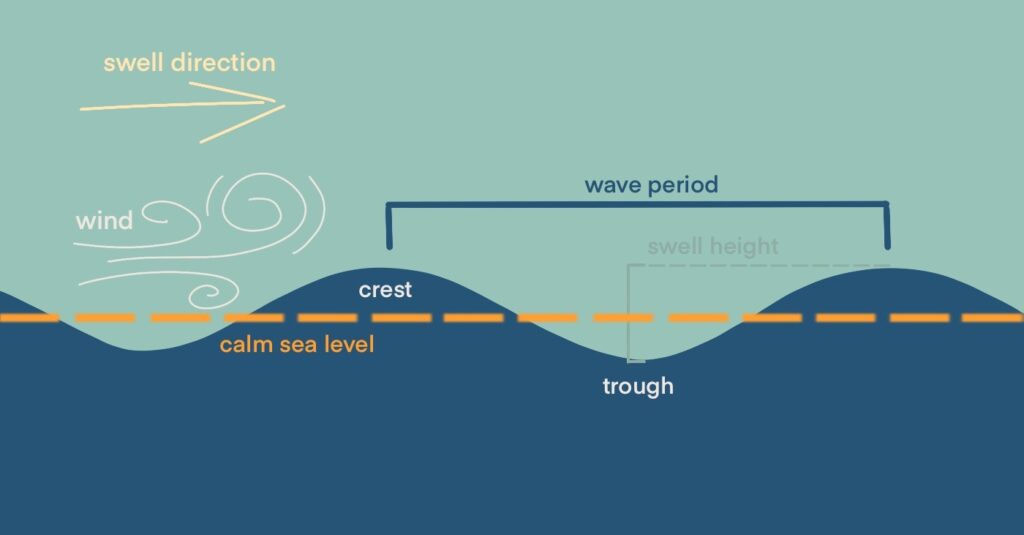
The swell direction from the right direction
Swell direction refers to the direction from which the swell is coming. It is either specified in cardinal directions such as north (N), northwest (NW) or as an angle in degrees: 0° or 360° stands for north, 90° for east, 180° for south and 270° for west. How well a swell direction works at a surf spot depends heavily on the orientation of the coast. If the swell hits the coast directly or head-on, the full wave energy can reach the surf spot. The waves are then orderly and powerful, forming clean, surfable waves. If the angle to the spot is too steep or slanted, the energy is weakened. Waves then often break uncleanly and chaotically or do not arrive properly at all.
You can find out more about how swell directions behave at your spot in our blog article on the wave refraction of ocean waves.
Wind – Game changer for perfect or chaotic waves
Wind is one of the decisive factors for the quality of waves – it can perfect them or completely destroy them. Because no matter how perfect the waves are created on the open sea, If the wind conditions are poor when the waves reach the surf zone, such as strong side or onshore winds, surfing enjoyment is greatly impaired. Aspects such as wind strength (also wind speed) and wind direction are crucial.
Important: Wind direction always describes the direction from which the wind is coming. Here is an overview of the most important wind types and their effects:
|
Wind designation
|
Definition (wind comes from ...)
|
Influence on waves and surfing experience
|
Further notes
|
|---|---|---|---|
|
Offshore wind
|
... from land towards the sea
|
Smooths out the waves, keeps them open, builds them up nicely. Clean, glassy waves and long rides are possible. Strong offshore winds make it difficult to paddle into the waves.
|
Mostly active in the morning / early morning due to nighttime cooling of the land
|
|
Onshore wind
|
... from the sea towards land
|
Breaks waves early, making them chaotic and choppy. The stronger the wind, the harder it is to surf, the worse, “mushy”
|
Most frequently in the afternoon when thermals are increasing
|
|
Sideshore wind
|
sideways to the coast (parallel)
|
Depending on the spot/swell direction, partly stabilizing, partly disruptive. Neutral to difficult, depending on the spot.
|
Can be okay at reef breaks or points, often choppy at beach breaks.
|
|
Cross-offshore wind
|
Sideways offshore (sideways offshore, as sideways from land towards sea)
|
Similar to offshore, but with a slight side pull. Waves remain open, but are slightly more difficult to surf.
|
More common in spots with a jagged coastline
|
|
Cross-onshore wind
|
Side-onshore
|
Waves become rougher, but often still surfable. Moderate, somewhat less chaotic than pure onshore, but mostly challenging.
|
Waves still surfable in strong swell
|
|
No Wind
|
Calm
|
Smooth surface, pure swell form. Fantastic, perfect conditions with good swell.
|
Frequently in calm morning or evening hours
|
At wind speeds below 5 knots (approximately 6 mph), the wind has little effect on the water surface – you can usually ignore it in the forecast. With sideshore winds, approximately 11 knots (are necessary for a noticeable effect on the wave structure, as these winds do not hit the waves head-on with full force, but rather from the side – here, much depends on the specific spot.
Tides – why high and low tide can determine a good session
Not every spot works equally well at every tide. The tides—ebb and flow—affect the waves because they influence the water level and thus how waves break at a particular spot. Most spots only work within a certain tidal window, e.g., at high tide or low tide. Both swell height and tides affect the waves. A larger swell can lead to more powerful and larger waves at high tide, breaking significantly further out than at low tide and potentially allowing for longer rides. High and low tides are subject to the gravitational pull of the moon and sun, causing constant movement of the ocean water. As a rule, high tide and low tide occur twice a day, with the tide shifting back by approximately 50 minutes the following day.
In short, the best time to surf depends not only on the swell but also on the tide. Those who combine both have a clear advantage when planning your sessions.
Probably the most important factor – local knowledge of the surf spot
The local conditions of a spot are probably the most important factor. They determine whether the wave forecast will be accurate as predicted. Since global wave models cannot take into account all the conditions of individual surf spots, local knowledge of your home spot is essential. To avoid disappointment when you see the waves at the beach and to improve your local knowledge, pay attention to the following points:
- Tide window and tide sensitivity: Observe how the surf spot behaves during the tides. If you know the tide window, you can surf the best waves.
- Swell size and swell direction: Some spots only work when the waves are of a certain size and direction! Try to recognize how the waves behave under different conditions and pay attention to the interaction between the tides and the size of the swell.
- Sandbanks that are constantly changing: Especially at beach breaks, sandbanks change regularly due to swell, tides, and currents.
- Swell filtering: Not every swell actually reaches the spot. Coastlines, offshore islands, or underwater structures deflect, block, or filter waves. Those familiar with the refraction and diffraction of ocean waves can better assess when and where a swell will work.
- Local wind phenomena: Sea breezes, thermals, or valley winds are often not accurately predicted. What was forecast as offshore can suddenly be sideshore or onshore when you arrive. Dunes, cliffs, or forests can provide additional protection from the wind.
- Currents and other hazards: Currents are not always bad – they often get you to the line-up quickly. But they are rarely mentioned in forecasts, as are other hazards such as sea creatures or rocks in the surf. Identify currents and talk to locals about other sources of danger. Does the low tide expose rocks or parts of the reef where you could injure yourself?
- Underwater structures: Such as sandbanks and reefs influence how ocean waves build and form. Important aspects include how solid the sandbank is, i.e., how high a swell can it withstand before there are only close-out waves?
If you understand a spot, you can turn an “okay” forecast into a perfect session – or know when it’s not worth going to the beach. Local knowledge is irreplaceable. It’s usually worth checking the surf report before you jump into the water with your board.
Other factors in surf forecasting
Other factors in a wave forecast
In addition to the factors mentioned above, there are other details that can influence your session:
- Main swell: also known as the main swell or primary swell, is usually the most powerful and relevant.
- Secondary swell: Secondary swell can also change the conditions – positively or negatively. If waves from different directions meet, more chaotic or complex wave formation can occur.
- Wind gusts: Can deviate greatly from the wind speed and briefly influence your surfing experience. e.g. roughen the water surface for a short time, make waves close faster or throw you off balance.
- Sunrise and sunset: Important for dawn-petrolers! Helpful if you are planning a sunrise and sunset session.
- Surf guides and spot description: Additional information about the spot can be particularly useful and provide details about the seabed, the conditions under which a spot works well (including wave size, swell direction and ideal tide conditions), the wave type, paddle intensity (current) and the vibe in the water.
- Air and water temperature: Not only important for wetsuit selection, but also helpful for good-weather surfers.
Summary
Wave quality is determined by a combination of several factors: The wind determines whether waves are clean and surfable—offshore wind smooths them out, while onshore wind makes them chaotic. The tide influences when a spot is good. Equally important are the size and direction of the swell—they determine how big and powerful the waves are.
But no forecast can replace local knowledge of the spot: sandbanks, wind protection, currents, or swell filtering by coastlines influence whether the forecast actually comes true. Those who understand how wind, swell, tide, and spot conditions interact can get the most out of a mediocre forecast – or know when it’s not worth going to the beach.